
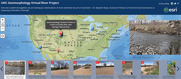
Due to the COVID-19 restrictions, the University of Northern Colorado has been finding creative ways to teach classes remotely. Students in Sharon Bywater-Reyes’, Ph.D., Geomorphology course made observations of rivers accessible to them during Colorado’s Stay-at-Home order, which were then compiled into a Map Tour online, using ESRI’s mapping tool.
The assignment required students to visit a local river in person — if it was safe, legal and the student felt comfortable doing so, or to visit a river via Google Earth. Students recorded their location and made a photo log with accompanying observations about the river, such as the name and evidence of river health and function.
Interact with the Map Tour that includes students' observations and photos:
“We weren’t able to go on our river trip, so I was trying to emulate the real-world
and important skill of making observations and applying lecture material to the real
world,” Bywater-Reyes said. “Plus, I wanted to get people out of their houses and
remind them why they study this stuff.”
The Map Tour online was created with GIS-mapping software, ESRI ArcGIS online, which includes a Map Tour function. A Map Tour is an online mapping tool that allows georeferenced photos to appear with a description and map. Students submitted their observations and georeferenced photos through a Canvas discussion board and Bywater-Reyes compiled the information into the map.
“I am happy we were able to connect while we were all spread out so far across the country and hope people enjoy the tour,” she said.
-- Written by Mackenzie Eldred
More Stories
-
Alumna Receives NSF Graduate Fellowship for Avian Conservation Research
Este artículo no está en español.
-
Alumna Receives NSF Graduate Fellowship for Avian Conservation Research
Este artículo no está en español.
-

Novel and Interdisciplinary Research on Transgender Health
Este artículo no está en español.
-
Grad Students Researching Methods to Strengthen Mental Health Training in Rural Schools
Este artículo no está en español.