
GIS students and faculty at the University of Northern Colorado are putting their skills to work, spearheading a humanitarian effort that will impact communities across the globe.
UNC, in partnership with Colorado State University and Front Range Community College, is gearing up for their annual Mapathon — an event where a group of people come together on a particular day to voluntarily work on a collective mapping project. The event, scheduled for Nov. 16, 4-6 p.m., is in support of Missing Maps, an open, collaborative project co-founded by the American Red Cross that empowers volunteers to map areas where humanitarian organizations are working.
“Some countries have very limited data structure and preparation that can be used for mitigation efforts in response to emergencies,” said Jieun Lee, associate professor in UNC’s Department of Geography, GIS and Sustainability. “Mapathons provide a place where volunteers come together to create that needed data for communities around the world so that local and international organizations and decision-makers can use these maps and data to better respond to crisis affecting these areas.”
The mapathon, part of NOCO GIS Days, is sponsored by UNC’s Department of Geography, GIS and Sustainability and is co-led this year by UNC students Sarah Karr and Joseph Andrade-Schuch, along with local map expert and guest speaker, Mike Thompson.
For Karr, a senior Psychology major with a double minor in Environmental Studies and GIS, and Andrade-Schuch, a senior Environmental and Sustainability Studies major, the event is an opportunity to not only exercise their leadership and GIS skills, but to be a part of something that has a global impact.
“I think this is a really cool thing for UNC to do, because it's solely humanitarian work,” Andrade-Schuch said. “And it's all volunteers who do this, so no one's getting paid. If there's ever a crisis in the area we’re mapping, we're the people who did that. That kind of work makes you feel good.”
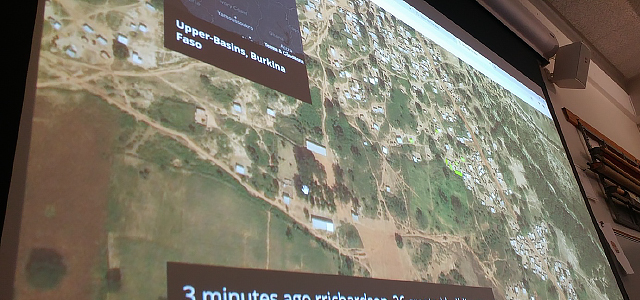
Part of their responsibilities as co-leads for the event was to choose what to map, and according to Karr, the process wasn’t easy. The two spent hours looking for the right project, scanning areas in South America, Central America, Africa, Europe and Australia, before settling on a mapping project in Nigeria.
“There are many things out there that need to be mapped and they are all very important, so it’s been hard to find the one that’s perfect for this mapathon,” Karr said. “We can’t really do intermediate or advanced mapping in this setting because not everyone is going to have the knowledge or skill for that. If you pick an area that’s too urban or too rural, it can get pretty tricky.”
According to Andrade-Schuch, this year’s mapping project will cover an extensive area containing mainly forested areas and farmland. Although there is some urban land, it’s not enough to raise the difficulty level of the mapping.
“This particular map was the perfect mix of everything,” he said. “So, no matter what your skill level is, there’s a little bit of something here for everybody.”
Both Andrade-Schuch and Karr emphasized that the event is open to anyone who wants to learn more about OpenStreetMap (OSM), how to create OSM data and digitize the new data for this project. They’ve even developed a step-by-step guide of standard operating procedures that will walk volunteers through the process. Attendance can be in-person at UNC’s GIS Lab in Candelaria Hall, room 2110, or virtual. No previous GIS experience is required but participants are encouraged to bring their own laptop and mouse as lab computers are limited.
“I think it'd be a lot of fun for people from the community to get involved in this,” Karr said. “It’s a chance to get to know college students and learn a little more about who we are, what we can do and just have the opportunity to teach more people about the potential of GIS.”
For food and planning purposes, registration for the event is required by Tuesday, Nov. 15. To learn more and register, visit NOCO GIS Days 2022.
— written by Deanna Herbert
More Stories
-

Daniel Garza’s Journey from Platteville, Colorado, to Stellenbosch, South Africa
Este artículo no está en español.
-
Governor Polis Reappoints Monfort and Campos-Spitze to UNC’s Board of Trustee
Este artículo no está en español.
-
UNC Choirs Brings Together Guest Musicians, Alumni, Students and Faculty for Major Works
Este artículo no está en español.
-

Week-Long Celebration to Honor First-Generation College Students
Este artículo no está en español.